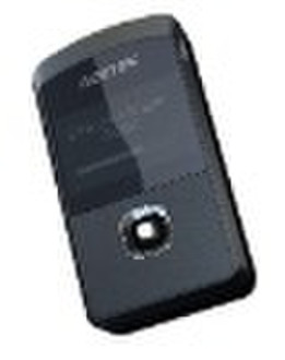
GPS logger

Cecilia He
Contact person
Basic Information
Functions: - GPS Positioning--- high sensitivity GPS positioning - Electronic Compass--- built-in electronic compass, for determining geographic direction. - Baric altimeter--- display the current air pressure - Thermometer--- displays current temperature - GPS data logger--- saving GPS data and interval programmable ( by time / distance) - Speedometer---displays the speed, mobile speed, stationary speed, mobile distance, average speed, average mobile speed, altitude, altitude track, target azimuth, and target distance etc.) - Directional navigation ( destination indicate, straight distance) - POI input setting - PC connectingPC software function - Can be as a GMOUSE - Coordinates in photo - Log data can be exported to Google map/ Google earth - Exporting and recording the data in KML format to share with others - POI download to device - Altitude changing display - Edit trackApplications - Climber can reference the altitude and direction, even report the coordinates for SOS - Bicycle rider use it as a stopwatch, saving speed and distance, even log the whole track, and share with others through Google Erath. - Add coordinates information into the photo. - Log the traveling track, and direction navigation. - Simple tracking --- vehicle or asset tracking by logging data - GMOUSE
Delivery terms and packaging
Packaging Detail: Accessory: USB cable, fixed band for bike, etcNetural paper box packing, carton for shepping. 20pcs per carton Delivery Detail: 20-40days

-
Payment Methods
We accept:


